Search

Search Results

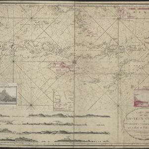
A New Chart of the Eastern Straits, or the Straits to the East of Java, with a part of the Banda Sea

event1798

location_onEast Timor, Indonesia

A late 18th century maritime navigation map of the straits east of Java, with drawings of the elevations of the straits. The map is also marked with routes of explorers, including the return of Captain Cook’s HMS Endeavour from Australia in 1770.

Plan of the road and city of Batavia on the north coast of Java Island

event1790

location_onIndonesia

Map of the Batavia (Jakarta) Bay roadstead, a body of water sheltered from tides/currents, for ships to anchor. The web of lines is a rhumbline network, the numbers indicate sea depth (bathymetry), and there are written notes, all to aid navigation.

Particular-see-charte der Strass Sunda, nebst denen darinnen befindlichen insulen und sandbäncken

event1744

location_onIndonesia

A navigation map of part of the north coast of Java, featuring the ports of Batavia (Jakarta) and Bantam (Serang). Includes colourful paintings of a ‘menschen fressers [cannibal]’ island, Javanese people and palm trees (dates, banana, coconut).

Deese wassende pas-kaart van Oost-Indien, is nu te bekoomen voor die deselve begeeren

eventc.1728-1738

location_onBrunei, Cambodia, East Timor, Indonesia, Laos, Malaysia, Myanmar, Papua New Guinea, Philippines, Singapore, Southeast Asia, Thailand, Vietnam

Map of the Indian Ocean dominated by a rhumbline network—a web of interconnected lines used to help plot routes—with a compass rose at the centre. At the top there are (incomplete) drawings of people with text in Dutch, French, English and Spanish.

De reede en stadt Batavia, is geleegen aan de noord kust van 't eyland Groot Iava inde Oost Indische Zee

event1728

location_onIndonesia

A map of the bay of the port city of Batavia (Jakarta). To aid navigation, a rhumbline network (the web of interconnected lines), bathymetry (sea depth), and small islands, shoals and reefs are marked. An inset map shows the city in more detail.

[Portolan chart of the Gulf of Siam]

event1697

location_onThailand, Vietnam, Malaysia, Cambodia

A brightly-coloured hand-drawn map of the Gulf of Siam, made for a ship’s captain. The elaborate compass roses are the centre of a rhumbline network, a web of lines to aid navigation. Bathymetry (sea depth), islands, shoals and reefs are also marked.

close