
Search Results
180 Results found


Topographische kaart der residentie Djokjakarta
1892
Indonesia
The residency of Djokjakarta (Yogyakarta), southern Java, featuring crops (coffee, sugar, rice, alang-alang, tobacco, indigo plants, nipa palm, bamboo); warehouses, cemeteries, post offices; routes, administrative borders; mountains, rivers.

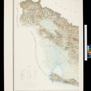
Topographische Kaart der residentie Pekalongan
1892
Indonesia
Topographic map of the residency of Pekalongan (Central Java), divided into regencies (pink borders) and districts (yellow borders). Mountains, forests, settlements, routes, crops—alang-alang, coffee, sugar, rice—factories and warehouses are shown.

Kaart van de Karo landen (Oost Sumatra)
1891
Indonesia
A map recording five Dutch expeditions through the Karo Lands of northern Sumatra. The mountainous terrain is represented by contour lines, with peaks’ heights marked. The names of groups of the indigenous Karo people are shown in large letters.


Kaart van het gebied bezet in Groot-Atjeh
1891
Indonesia
A map of Groot-Atjceh and the city of Kota Radja (modern Banda Aceh) at the northern tip of Sumatra, detailing routes (rivers, roads, railways), crops (rice, banana, sugarcane, betel, reed, alang-alang, bamboo) and land features (forests, wetlands).


[Omgeving van het Toba meer, afdeelingen Bataklanden, onderafdeelingen Samosir, Toba en Hoogvlakte van Toba]
1890
Indonesia
Hand-drawn map of the southern part of Lake Toba in Sumatra, with roads, rivers and paths marked. Mountains, forest and rice fields are also shown, as are missionary buildings for indigenous and European people.

- Filter from 1670 to 1899
- Railway Station26
- Port25
- Pier13
- [remove]Path180
- Road169
- River167
- Postal Route73
- Railway/Tramway59
- Canal28
- Bridge26
- Telegraph/Telephone17


