Search

Search Results

Kaart van het gebied bezet in Groot-Atjeh

event1891

location_onIndonesia

A map of Groot-Atjceh and the city of Kota Radja (modern Banda Aceh) at the northern tip of Sumatra, detailing routes (rivers, roads, railways), crops (rice, banana, sugarcane, betel, reed, alang-alang, bamboo) and land features (forests, wetlands).

Oudheidkundige Kaart van West en Midden Java

event1891

location_onIndonesia

This map of western and central Java uses red symbols to mark the locations of antiquarian sites, including tjandis (Hindu tombs), walls, terraces, fortifications, temples, wells, statues and cemeteries. Rivers, roads and railways are also shown.

Oudheidkundige kaart van Oost-Java tot aan de vorstenlanden

event1891

location_onIndonesia

This map of eastern Java uses red symbols to mark the locations of antiquarian sites, including tjandis (Hindu tombs), walls, terraces, fortifications, temples, wells, statues and cemeteries. Rivers, roads and railways are also shown.

Oudheidkundige Kaart van West en Midden Java

event1890

location_onIndonesia

This map of western and central Java uses red symbols to mark the locations of antiquarian sites, including tjandis (Hindu tombs), walls, terraces, fortifications, temples, wells, statues and cemeteries. Rivers, roads and railways are also shown.

Sumatra

event1889

location_onIndonesia

Map of the city of Padang on the west coast of Sumatra, with inset maps of the nearby islands, featuring residential, business, government and military areas. There are also agricultural areas with coconut, nutmeg, bamboo, nipa palm and sago palm.

Oudheidkundige kaart van Oost-Java tot aan de vorstenlanden

event1889

location_onIndonesia

This map of eastern Java uses red symbols to mark the locations of antiquarian sites, including tjandis (Hindu tombs), walls, terraces, fortifications, temples, wells, statues and cemeteries. Rivers, roads and railways are also shown.

Plan topographique de l'arrondissement de Saigon

event1885

location_onVietnam

Map of the district of Saigon (Ho Chi Minh City, Vietnam), based around the Fleuve Soirap (Soài Rạp River) as it winds its way down to the South China Sea. The city of Saigon is on its banks, surrounded by more rivers, roads, fields and villages.

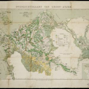
Overzichtskaart van Groot-Atjeh

event1884

location_onIndonesia

Map of Groot-Atjeh (Aceh, Sumatra) divided into administrative districts. Mountains, forests, villages, railways, roads and rivers are marked. There are inset maps of Poeloe Bras (Breueh Island), and showing distances between larger settlements.

Kaart van het terrein des oorlogs in Groot-Atjeh

event1883

location_onIndonesia

The Aceh War (1873–1904) between the Sultanate of Aceh and Dutch colonists is highlighted on this map of Groot-Atjeh in 1876. Flag symbols mark the locations of Dutch military posts, and some villages are described as ‘verbrande [burnt]’.

Kaart van het terrein des oorlogs in Groot-Atjeh in 1876

event1883

location_onIndonesia

The Aceh War (1873–1904) between the Sultanate of Aceh and Dutch colonists is highlighted on this map of Groot-Atjeh in 1876. Flag symbols mark the locations of Dutch troops, while a red line records the route marched by ‘agitating troops’ in 1875-6.

Kaart van het terrein des Oorlogs in Groot-Atjeh in 1876

event1883

location_onIndonesia

The Aceh War (1873–1904) between the Sultanate of Aceh and Dutch colonists is highlighted on this map of Groot-Atjeh in 1876. Flag symbols mark the locations of Dutch troops, while a red line records the route marched by ‘agitating troops’ in 1875-6.

Kaart van Malang en Omstreken

event1882

location_onIndonesia

Map of the city of Malang, Java, featuring the railway station, military camp, hospital, market etc. The surrounding area has villages, rivers and crops: rice (paddy) fields, coffee, alang-alang, bamboo. Red numbers represent height above sea-level.

close