
Search Results
56 Results found


Algemeene kaart van Nederlandsch Oostindie
c.1839-1855
East Timor, Indonesia, Malaysia, Singapore
This map of the Dutch East Indies is spread over eight sheets, with a hand-drawn cover sheet showing the whole area. There are numerous inset maps of islands, bays, cities etc. Two of the inset maps have a replacement map pasted over them.

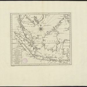
Nieuwe en Naukeurige Kaart der Oost-Indische Eilanden
1774
Brunei, Cambodia, East Timor, Indonesia, Laos, Malaysia, Myanmar, Philippines, Singapore, Southeast Asia, Thailand, Vietnam
Some regions on this map of Southeast have a descriptive label: New Guinea is described as unknown to Europeans; Borneo was abandoned by Europeans due to the ‘unmanageability’ of the inhabitants; the Philippines were discovered by Spain in 1565.

Nieuwe en naukeurige kaart van Asia
1773
Indonesia, Brunei, Cambodia, East Timor, Laos, Malaysia, Myanmar, Papua New Guinea, Philippines, Singapore, Southeast Asia, Thailand, Vietnam
Map of Asia featuring an early—and very vague—depiction of New Britain (‘Nieuw Brittanje’) which was named by the British explorer William Dampier when he visited in 1700. The ‘Straat van Dampier’ is also shown, dividing New Britain from New Guinea.
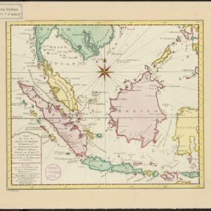
Carte des Isles de Java, Sumatra, Borneo &a. Les detroits de la Sunde, Malaca, et Banca, Golfe de Siam &a.
1773
Brunei, Cambodia, Indonesia, Malaysia, Singapore, Thailand, Vietnam, Philippines
This map shows the islands of Java, Sumatra and Borneo, the straits of Sunda, Malacca and Bangka, and the Gulf of Siam. The title is given in both French and Dutch, as are some of the place names on the map.
Nieuwe en naukeurige kaart van Asia
1773
Indonesia, Brunei, Cambodia, East Timor, Laos, Malaysia, Myanmar, Papua New Guinea, Philippines, Singapore, Southeast Asia, Thailand, Vietnam
Map of Asia featuring an early—and very vague—depiction of New Britain (‘Nieuw Brittanje’) which was named by the British explorer William Dampier when he visited in 1700. The ‘Straat van Dampier’ is also shown, dividing New Britain from New Guinea.
Carte des Isles de Java, Sumatra, Borneo &a. Les detroits de la Sunde, Malaca, et Banca, Golfe de Siam &a.
1773
Brunei, Cambodia, Indonesia, Malaysia, Singapore, Thailand, Vietnam, Philippines
This map shows the islands of Java, Sumatra and Borneo, the straits of Sunda, Malacca and Bangka, and the Gulf of Siam. The title is given in both French and Dutch, as are some of the place names on the map.

Carte des Isles de Java, Sumatra, Borneo &a. Les detroits de la Sunde, Malaca, et Banca, Golfe de Siam &a.
c.1772-1780
Brunei, Cambodia, Indonesia, Malaysia, Philippines, Singapore, Thailand, Vietnam
This map shows the islands of Java, Sumatra and Borneo, the straits of Sunda, Malacca and Bangka, and the Gulf of Siam. The title is given in both French and Dutch, as are some of the place names on the map.

Nieuwe en naukeurige kaart der Oost-Indische Eilanden
c.1770
Brunei, Cambodia, East Timor, Indonesia, Laos, Malaysia, Myanmar, Philippines, Singapore, Southeast Asia, Thailand, Vietnam
Some regions on this map of Southeast have a descriptive label: Sumatra is described as having mines of gold, silver, iron, and sulphur; and elephants, tigers, rhinoceroses, dragons and crocodiles. Gilolo has rice, sago and turtles. Ambon has nutmeg.
- Filter from 1595 to 1842
- [remove]Malaysia56
- Indonesia55
- Brunei52
- Cambodia51
- Singapore51
- Thailand51
- Vietnam47
- Philippines45
- East Timor39
- Laos36
- Myanmar36
- Southeast Asia35
- more Simple Location »
- [remove]Compass Rose56
- [remove]Longitude and Latitude56
- Scale46
- Rhumbline Network16
- Written Note/Details13
- Contour Lines/Elevation2


