
Search Results


Asiatic archipelago
1858
Vietnam, Myanmar, Papua New Guinea, Philippines, Singapore, Southeast Asia, Thailand, Malaysia, Laos, Indonesia, East Timor, Cambodia, Brunei
This late 19th century map of Southeast Asia shows the best maritime routes around the region, according to the time of year. There are also inset maps highlighting the rivers and southern islands of Singapore, and the sea depth around Labuan Island.

Kaart van de Residentie Bezoeki en de Afdeeling Banjoewangi
1856
Indonesia
Map of the Dutch colonial administrative regions of Bezoeki (Besuki) and Banjoewangi (Banyuwangi), on Java. Includes an elevation view of the mountains. (From ‘Algemeene Atlas van Nederlandsche Indie [General Atlas of the Dutch East Indies]’.)
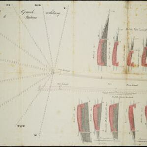
Plan voor eene generale verbetering der zeehoofden te Batavia
1856
Indonesia
A hand-drawn plan for improvements to the pier at the port in Batavia (Jakarta), showing profiles of stone and concrete walls/buttresses to be built along the sides of the ‘Haven Kanaal [Harbour Canal]’. Blue lines on the profiles mark water level.


Kaart van de Afdeeling Ngrowo (Residentie Kediri)
1855
Indonesia
Map of the administrative department of Ngrowo, Java. A list gives heights above sea level of some mountains and villages, and a note locates a sugar factory. (From ‘Algemeene Atlas van Nederlandsche Indie [General Atlas of the Dutch East Indies]’.)


Algemeene Atlas van Nederlandsche Indie
c.1853-1862
Indonesia
Atlas featuring over 60 detailed maps of the Dutch East Indies: 24 maps cover Java; the remainder cover the rest of the Dutch East Indies. There are three index maps. (All the maps in this atlas are also presented separately on this platform.)


- Filter from 1535 to 1899
- Indonesia199
- Malaysia139
- Singapore136
- Brunei130
- Philippines129
- East Timor127
- Vietnam124
- Cambodia123
- Southeast Asia123
- Thailand123
- Laos121
- Myanmar121
- more Simple Location »
- [remove]Written Note/Details200
- Longitude and Latitude176
- Scale137
- Compass Rose67
- Contour Lines/Elevation50
- Rhumbline Network23


