Search

Search Results

Carta particolare del mare d'India sino allo stretto di Sunda fra l'Isole di Sumatra è di Iaua maggre

event1646

location_onIndonesia

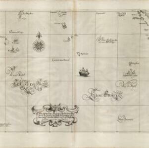
Apart from some small islands, this mid-17th century Italian map of the Indian Ocean features no land other than the islands of Sumatra and Java in the top right corner. Text on the map refers to winds (‘Venti’) and currents (‘Corrente’).

Carte hydro-geo-graphique des Indes orientales, en deca̧ et au dela du Gange avec leur archipel

event1771

location_onBrunei, Cambodia, East Timor, Indonesia, Laos, Malaysia, Myanmar, Philippines, Singapore, Southeast Asia, Thailand, Vietnam

The arrows on this map show the direction of the seasonal monsoons of Southeast Asia during the late 18th century. Each arrow has a label in French, indicating the month. The hatched sea areas are where the winds always blow in the same direction.

Carte du sisteme des courants des Mers de l'Inde dans le tems de la Mousson du N.E, au N. de la ligne

event1776

location_onIndonesia, Myanmar, Thailand

Map of the Indian Ocean showing the currents (represented by arrows) and winds (represented with letters A to G) during the monsoon seasons. Three routes from the Isle de France (Mauritius) around the Indian Ocean are shown.

Carte du sisteme des courants des Mers de l'Inde dans le tems de la Mousson du N.E, au N. de la ligne

event1776

location_onMyanmar, Indonesia, Thailand

Map of the Indian Ocean showing the currents (represented by arrows) and winds (represented with letters A to G) during the monsoon seasons. Three routes from the Isle de France (Mauritius) around the Indian Ocean are shown.

Carte des courants pour le tems de la Mousson du S.O., au N. de la ligne

eventc.1780

location_onMalaysia, Indonesia, Myanmar, Thailand

Map of the Indian Ocean showing the currents (represented by arrows) and winds (represented with letters A to F) during the monsoon seasons. Three routes—one old and two new—from the Isle de France (Mauritius) east to the Strait of Malacca are shown.

A chart of the currents in the Indian Sea during the southwest monsoon, to the northward of the line / A chart of the currents in the Indian Sea during the northeast monsoon, to the northward of the line

event1794

location_onMalaysia, Indonesia, Myanmar, Thailand

Two maps of the Indian Ocean showing currents (represented by arrows) and winds (represented by letters A to F) during the monsoon seasons. Three routes—one old and two new—from the Isle de France (Mauritius) east to the Strait of Malacca are shown.

Chart of the East India Islands: exhibiting the several passages between the Indian and Pacific Oceans

event1824

location_onBrunei, Cambodia, East Timor, Indonesia, Malaysia, Philippines, Singapore, Thailand, Vietnam, Southeast Asia, Myanmar

To aid navigation, this map shows small islands, shoals and reefs, maritime routes for use during monsoons or at particular times of the year, bathymetry (sea depth), past explorers’ routes, shipwrecks and text about monsoons, typhoons and currents.

Carte des courants généraux dans l'Océan Indien

eventc.1849-1863

location_onBrunei, Cambodia, East Timor, Indonesia, Laos, Malaysia, Myanmar, Philippines, Singapore, Southeast Asia, Thailand, Vietnam

Map of the Indian Ocean showing the currents (represented by arrows), including during the North East and North West monsoons. Numbers on the arrows indicate the current’s speed.

Geographical distribution of the currents of air

event1849

location_onBrunei, Cambodia, East Timor, Indonesia, Laos, Malaysia, Myanmar, Papua New Guinea, Philippines, Singapore, Southeast Asia, Thailand, Vietnam

A world map showing winds, hurricanes and typhoons, including trade winds, calms, typhoon, monsoon and hurricane regions in Southeast Asia. An inset map shows the approach of the Rodriguez Hurricane towards Java in 1843.

Physical chart of the Indian Ocean: shewing the temperature of the water, the currents of the air and ocean, directions of the wind, districts of hurricanes, regions of the monsoons & ty-foons, trade routes &c&c.

event1849

location_onBrunei, Cambodia, East Timor, Indonesia, Laos, Malaysia, Myanmar, Papua New Guinea, Philippines, Singapore, Southeast Asia, Thailand, Vietnam

Chart of the Indian Ocean, showing climate and weather-related data, including around the seas and straits of Southeast Asia where trade routes are marked, along with monsoon and typhoon regions, and currents during the different monsoon seasons.

close