
Search Results


Itinéraires de Mr A. Pavie dans le Sud-Ouest l'Indo-Chine Orientale (Cambodge et Siam) (1880-1884)
1884
Thailand, Cambodia
The routes taken by the French civil servant and explorer Auguste Pavie are marked on this map of Siam (Thailand) and Cambodge (Cambodia), along with the telegraph line that he subsequently constructed from Pnom Penh (Phnom Penh) to Bangkok.

Carte physique et politique de l'Asie
1822
Brunei, Cambodia, Indonesia, Laos, Malaysia, Myanmar, Papua New Guinea, Philippines, Singapore, Thailand, Vietnam, Southeast Asia
This map of Asia features the ancient kingdoms of mainland Southeast Asia, such as the Birman Empire, Siam, Tonquin and Cochinchina. There are labels noting the inhabitants of some areas, such as 'Biajos' and ‘Tedongs’ in Borneo, and ‘Kemoy’ in Anam.

Carte de l'Archipel des Indes Orientales, représentant les différens passages entre l'Ocean Indien et le Grand Océan
c.1804
Brunei, Cambodia, East Timor, Indonesia, Laos, Malaysia, Myanmar, Philippines, Singapore, Southeast Asia, Thailand, Vietnam
Map focusing on the passages between the islands of maritime Southeast Asia used to travel between the Indian and Pacific oceans. Includes the Strait of Malacca, many straits between the Sunda Islands, and a route through the Maluku Islands.

Asie divisée en ses Empires, Royaumes et Etats
1794
Brunei, Cambodia, East Timor, Indonesia, Laos, Malaysia, Myanmar, Philippines, Singapore, Southeast Asia, Thailand, Vietnam
This map of Asia features a decorative cartouche with drawings of two women—one with a cornucopia and one with a censer (incense burner)—and a French coat of arms. Interestingly, the map is dated 1792, during the French Revolution.

Asie divisée en ses principaux Etats, Empires & Royaumes
1791
Brunei, Cambodia, East Timor, Indonesia, Laos, Malaysia, Myanmar, Philippines, Singapore, Southeast Asia, Thailand, Vietnam
A late 18th century map of Asia, with notes on the principal states, empires and kingdoms of Asia written in French on the right-hand side.

Asie
c.1790
Brunei, East Timor, Cambodia, Indonesia, Laos, Malaysia, Myanmar, Philippines, Singapore, Southeast Asia, Thailand, Vietnam
This map of Asia features four different scales: French, Russian, Turkish and Chinese. Each country had their own measuring system, so this was not uncommon at the time.
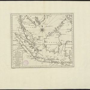
Carte des Isles de Java, Sumatra, Borneo &a. Les detroits de la Sunde, Malaca, et Banca, Golfe de Siam &a.
1773
Brunei, Cambodia, Indonesia, Malaysia, Singapore, Thailand, Vietnam, Philippines
This map shows the islands of Java, Sumatra and Borneo, the straits of Sunda, Malacca and Bangka, and the Gulf of Siam. The title is given in both French and Dutch, as are some of the place names on the map.


