Search

Search Results

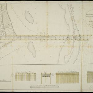
Situatie-kaart van een gedeelte der stad Batavia benevens de bank voor de Groote rivier

event1817

location_onIndonesia

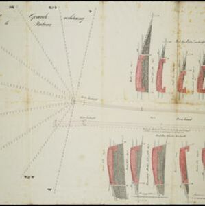
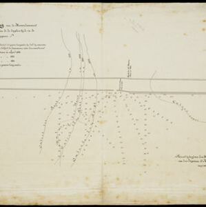
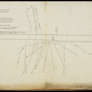
Plan of the canals and rivers flowing through the city of Batavia (Jakarta), passing through the port before reaching the pier and the bay. The bay has a sand bank and figures for water depth. There are profile drawings of two of the city’s rivers.

Schets der verrigte werkzaamheden aan de zee hoofden op de bank voor de Groote rivier te Batavia

event1822

location_onIndonesia

Plan of improvements made to the pier at the port in Batavia (Jakarta): red lines show new parts added in 1822; numbers record the change in water depth (red is 1818; black is 1822). Planned future works and the ‘Waterkasteel’ fort are also shown.

Schetze van de bank met derzelver uitbreiding zedert 1817 voor de Groote rivier te Batavia, benevens de geprojekteerde en gedeeltelijk geexecuteerde zee-hoofden

event1823

location_onIndonesia

Plan of improvements made to the pier at the port in Batavia (Jakarta): red lines show new parts added in 1822; numbers record the change in water depth (red is 1818; black is 1823). Planned future works and the ‘Waterkasteel’ fort are also shown.

Schetze van de nieuwgemaakte zeehoofden en een gedeelte der bank voor de Groote rivier te Batavia met derzelver uitbreiding zedert 1817 tot 1823

event1823

location_onIndonesia

Plan of improvements made to the pier at the port in Batavia (Jakarta), including profile drawings of the construction parts. Lines indicate the changing position of the beach and the sandbank over the years, and numbers show the water depth.

Kaart van Onrust en bijliggende eilanden in het jaar 1837

event1840

location_onIndonesia

Map of the Dutch town and naval base on the island of Onrust in Batavia (Jakarta) Bay, and adjacent islands, featuring the dock, boat and work sheds, ammunition stores, forge, hospital and housing. Shoals, reefs and bathymetry (sea depth) are marked.

Plan voor eene generale verbetering der zeehoofden te Batavia

event1856

location_onIndonesia

A hand-drawn plan for improvements to the pier at the port in Batavia (Jakarta), showing profiles of stone and concrete walls/buttresses to be built along the sides of the ‘Haven Kanaal [Harbour Canal]’. Blue lines on the profiles mark water level.

Situatie-teekening van de havendammen te Batavia

event1864

location_onIndonesia

Plan of the pier at the port of Batavia (Jakarta). Lines indicate the changing position of the beach and the sandbank over the years, and numbers show the water depth (red numbers=measured in the year 1823, blue=1831 and black=1864).

Situatie-teekening van het Haven-kanaal

event1864

location_onIndonesia

Plan of the pier at the port of Batavia (Jakarta). Lines indicate the changing position of the beach and the sandbank over the years, and numbers show the water depth (red numbers=measured in the year 1823, blue=1831 and black=1864).

Situatie kaart van een gedeelte der stad Batavia

event1874

location_onIndonesia

Map of the coastline of the bay of Batavia (Jakarta) showing the extension of the port’s pier (in red, labelled CD), the sand and mud bank and bathymetry (sea depth) in the bay, and notes regarding changes in tide levels over the years.

Westkust Borneo: Mond der Padang-Tikar rivier

event1884

location_onIndonesia

Navigation map of the mouth of the Padang Tikar River, on the west coast of Borneo, featuring bathymetric (water depth) routes. Obstructions are marked with letters: ‘m’ (mud), ‘z’ (sand). Trees, hills and fishermen’s houses are shown as landmarks.

Kaart der Karimon-Djawa eilanden

event1887

location_onIndonesia

Map of the Karimunjawa Islands (Java Sea) marked with the locations of shoals, reefs, anchor points and sea depth (bathymetry) to aid navigation; and with geological sites (recent rock/coral formation, basalt rock, schist rock and quartz).

close

  • Filter from 1817 to 1899

Current results range from 1817 to 1899