
Search Results


Carte des Routes dans l'Océan Indien
c.1849-1863
Brunei, Cambodia, East Timor, Indonesia, Laos, Malaysia, Myanmar, Papua New Guinea, Philippines, Singapore, Southeast Asia, Thailand, Vietnam
Map of the Indian Ocean showing maritime routes, including some to and around Southeast Asia, where they pass through the Strait of Malacca, the Sunda Strait, and the straits between the Lesser Sunda Islands.

Physical chart of the Indian Ocean: shewing the temperature of the water, the currents of the air and ocean, directions of the wind, districts of hurricanes, regions of the monsoons & ty-foons, trade routes &c&c.
1849
Brunei, Cambodia, East Timor, Indonesia, Laos, Malaysia, Myanmar, Papua New Guinea, Philippines, Singapore, Southeast Asia, Thailand, Vietnam
Chart of the Indian Ocean, showing climate and weather-related data, including around the seas and straits of Southeast Asia where trade routes are marked, along with monsoon and typhoon regions, and currents during the different monsoon seasons.

Physical chart of the Pacific Ocean or Great Sea (Mare Pacifico): Showing the currents & temperature of the ocean, the trade routes &c.
1849
East Timor, Indonesia, Papua New Guinea, Philippines
Chart of the Pacific Ocean, showing climate and weather-related data, including around the seas and straits of eastern Southeast Asia where maritime trade routes are marked, along with monsoon regions, ocean temperatures and currents.

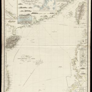
A chart of the Indian and Pacific Oceans with particular plans of the harbours
1847
Brunei, Cambodia, East Timor, Indonesia, Laos, Malaysia, Myanmar, Papua New Guinea, Philippines, Southeast Asia, Singapore, Thailand, Vietnam
Southeast Asia is shown on sheets two and three of this 12-sheet map of the Indian and Pacific oceans, including detailed inset maps of the straits of Singapore, Bangka, Gaspar and Sunda, with bathymetry (sea depth), shoals, reefs, anchorages etc.

Asiatic archipelago
1840
Vietnam, Myanmar, Papua New Guinea, Philippines, Singapore, Southeast Asia, Thailand, Malaysia, Laos, Indonesia, East Timor, Brunei, Cambodia
This late 19th century map of Southeast Asia shows the best maritime routes around the region, according to the time of year. There is also an inset map highlighting the rivers and southern islands of Singapore.
Reduzirte Karte vom Chinesischen Meere: 2tes Blatt, den Nördlichen Theil enthalted
1835
Vietnam, Philippines
Navigation map of the northern South China Sea, with bathymetry (sea depth), islands, shoals and reefs. There are five maritime routes to Canton and one to Manilla marked, and inset maps of the Gulf of Tonkin and bays and islands in the Philippines.

Carte generale de l'Asie: où se trouvent les découvertes faites par Bougainville, Dampier et La Pérouse
1833
Brunei, Cambodia, East Timor, Indonesia, Laos, Malaysia, Myanmar, Papua New Guinea, Philippines, Singapore, Southeast Asia, Thailand, Vietnam
This map of Asia is marked with the routes taken through Southeast Asia by the British Royal Navy captain James Cook, and the French explorer Lapérouse. The title also refers to two other explorers: Louis Antoine de Bougainville and William Dampier.

Reduzirte Karte von den Philippinen und den Sulu Inseln
1832
Malaysia, Indonesia, Philippines
Maritime map of the Philippines, with inset maps of bays showing bathymetry (sea depth), shoals, reefs and anchor points. There is also an inset map of Taal Volcano, and elevations (side views of terrestrial landmarks like mountains and islands).

Asiatic archipelago
1832
Vietnam, Myanmar, Papua New Guinea, Philippines, Singapore, Southeast Asia, Thailand, Malaysia, Laos, Indonesia, East Timor, Cambodia, Brunei
This late 19th century map of Southeast Asia shows the best maritime routes around the region, according to the time of year. There is also an inset map highlighting the rivers and southern islands of Singapore.
- [remove]Philippines40
- Indonesia32
- Malaysia30
- Vietnam30
- Cambodia28
- Brunei26
- East Timor26
- Thailand26
- Singapore25
- Laos24
- Myanmar24
- Southeast Asia24
- more Simple Location »
- Port8
- [remove]Maritime Route40
- Bathymetry21
- Current Data6
- Tide Data3


