Search

Search Results

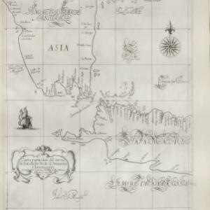
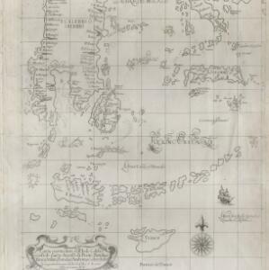
Carta particolare dell' Isole Celebes è Giliolo parte Austrle. è di Buttō, Batuliar, Timor, Seram, Banda, è Amboina è aItre Isolete

event1646

location_onIndonesia, East Timor

This mid-17th century Italian map shows the eastern islands of maritime Southeast Asia. Text on the map refers to winds (‘Venti’), currents (‘Corrente’) and air temperature (‘L'Aria è Calda e Humida [The air is hot and humid]’).

Carta particolare del stretto di Sunda fra l'Isole di Sumatra é Iaua maggre

event1661

location_onIndonesia

This mid-17th century Italian map is from Sir Robert Dudley's atlas ‘Dell'arcano del Mare’. It shows the Sunda Strait (‘Stretto di Sunda’) between the Southeast Asian islands of Sumatra and Java. Text on the map refers to currents (‘Corrente’).

Carte de la Côte de Pégou, et de celle de Martaban

event1775

location_onMyanmar

Navigation map of the coast of the ancient kingdom of Pégou and near the town of Martaban (Mottama), Myanmar. Bathymetry (sea depth), anchor points, notes on currents and obstructions are marked, and there are drawings of side views of coastal hills.

Chart... Shewing the Connection and respective distances by Sea, between the principal harbours and Settlements in the East Indies

event1794

location_onThailand, Myanmar, Malaysia, Indonesia

Maritime routes had to be adjusted in response to the changing monsoon seasons, as is seen on this late 18th century map of the Indian Ocean. Drawings of the heads of children blowing—called ‘wind-heads’—are used to indicate wind direction.

A new chart of the straits of Sunda: From the manuscript of the Dutch East India Company

event1794

location_onIndonesia

Navigation chart of the Sunda Strait, showing bathymetry (sea depth), shoals and reefs, landmarks, and a rhumbline network. Notes record good anchorages, sources of water and supplies etc. Inset map of the Zutphen Islands off the coast of Sumatra.

Map of the River of Don-nai from Cape St. James to the city of Saigon

event1820

location_onVietnam

A map to aid in the navigation of the rivers leading to Saigon (Ho Chi Minh City, Vietnam). Details include bathymetry (water depth), currents, and a side view (or ‘elevation’) of hills to use as a landmark. Tides are described in written remarks.

Chart of the East India Islands: exhibiting the several passages between the Indian and Pacific Oceans

event1824

location_onBrunei, Cambodia, East Timor, Indonesia, Malaysia, Philippines, Singapore, Thailand, Vietnam, Southeast Asia, Myanmar

To aid navigation, this map shows small islands, shoals and reefs, maritime routes for use during monsoons or at particular times of the year, bathymetry (sea depth), past explorers’ routes, shipwrecks and text about monsoons, typhoons and currents.

A chart of the Indian and Pacific Oceans with particular plans of the harbours

event1847

location_onBrunei, Cambodia, East Timor, Indonesia, Laos, Malaysia, Myanmar, Papua New Guinea, Philippines, Southeast Asia, Singapore, Thailand, Vietnam

Southeast Asia is shown on sheets two and three of this 12-sheet map of the Indian and Pacific oceans, including detailed inset maps of the straits of Singapore, Bangka, Gaspar and Sunda, with bathymetry (sea depth), shoals, reefs, anchorages etc.

Carte des courants généraux dans l'Océan Indien

eventc.1849-1863

location_onBrunei, Cambodia, East Timor, Indonesia, Laos, Malaysia, Myanmar, Philippines, Singapore, Southeast Asia, Thailand, Vietnam

Map of the Indian Ocean showing the currents (represented by arrows), including during the North East and North West monsoons. Numbers on the arrows indicate the current’s speed.

Physical chart of the Indian Ocean: shewing the temperature of the water, the currents of the air and ocean, directions of the wind, districts of hurricanes, regions of the monsoons & ty-foons, trade routes &c&c.

event1849

location_onBrunei, Cambodia, East Timor, Indonesia, Laos, Malaysia, Myanmar, Papua New Guinea, Philippines, Singapore, Southeast Asia, Thailand, Vietnam

Chart of the Indian Ocean, showing climate and weather-related data, including around the seas and straits of Southeast Asia where trade routes are marked, along with monsoon and typhoon regions, and currents during the different monsoon seasons.

Physical chart of the Pacific Ocean or Great Sea (Mare Pacifico): Showing the currents & temperature of the ocean, the trade routes &c.

event1849

location_onEast Timor, Indonesia, Papua New Guinea, Philippines

Chart of the Pacific Ocean, showing climate and weather-related data, including around the seas and straits of eastern Southeast Asia where maritime trade routes are marked, along with monsoon regions, ocean temperatures and currents.

close