
Search Results
Filter
Map Attributes
Written Note/Details
Remove constraint Map Attributes: Written Note/Details
Map Maker
Johnston, William
Remove constraint Map Maker: Johnston, William
Insets
Legend
Remove constraint Insets: Legend
Simple Location
East Timor
Remove constraint Simple Location: East Timor
13 Results found


Physical chart of the Indian Ocean: shewing the temperature of the water, the currents of the air and ocean, directions of the wind, districts of hurricanes, regions of the monsoons & ty-foons, trade routes &c&c.
1849
Brunei, Cambodia, East Timor, Indonesia, Laos, Malaysia, Myanmar, Papua New Guinea, Philippines, Singapore, Southeast Asia, Thailand, Vietnam


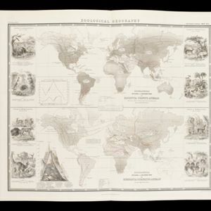
The geographical distribution of plants according to Humboldt's statistics of the principal families and groups: Schouw's twenty five phyto-geographic regions, and the distribution of the family of palms and the genera Pinus (pine) & Erica (heath)
1849
Brunei, Cambodia, East Timor, Indonesia, Laos, Malaysia, Myanmar, Papua New Guinea, Philippines, Singapore, Southeast Asia, Thailand, Vietnam

Survey of the geographical distribution and cultivation of the most important plants which are used as food for man: with indications of the isotheres & isochimenes, or lines of equal summer & winter temperature
1849
Brunei, Cambodia, East Timor, Indonesia, Laos, Malaysia, Myanmar, Papua New Guinea, Philippines, Singapore, Southeast Asia, Thailand, Vietnam

- [remove]East Timor13
- Indonesia13
- Philippines13
- Brunei12
- Cambodia12
- Laos12
- Malaysia12
- Myanmar12
- Papua New Guinea12
- Singapore12
- Southeast Asia12
- Thailand12
- more Simple Location »
- [remove]Legend13
- Illustration7
- Inset Map5
- Longitude and Latitude13
- [remove]Written Note/Details13
- Contour Lines/Elevation3
- Scale2


