
Search Results

Geographical distribution of the currents of air
1849
Brunei, Cambodia, East Timor, Indonesia, Laos, Malaysia, Myanmar, Papua New Guinea, Philippines, Singapore, Southeast Asia, Thailand, Vietnam
A world map showing winds, hurricanes and typhoons, including trade winds, calms, typhoon, monsoon and hurricane regions in Southeast Asia. An inset map shows the approach of the Rodriguez Hurricane towards Java in 1843.
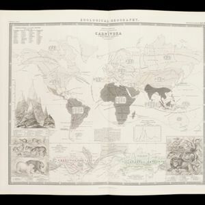
Zoological Geography: Sheet No. 2: Geographical division & distribution of Carnivora (carnivorous animals)
1849
Brunei, Cambodia, East Timor, Indonesia, Laos, Malaysia, Myanmar, Papua New Guinea, Philippines, Singapore, Southeast Asia, Thailand, Vietnam
A world map showing distribution of carnivorous animals, including in Southeast Asia. Tables list names of species found in each region; their geographical ranges are marked on the map. There is a drawing of 17 carnivore species of the ‘Old World’.

Mountain chains in Asia & Europe
1849
Cambodia, Indonesia, Laos, Malaysia, Myanmar, Philippines, Singapore, Thailand, Vietnam
Mountain chains are represented by black lines; volcanoes by black dots. Three insets maps: expansion of Reguain—island of Taung-ywa, off the coast of Myanmar—due to volcanic activity; geology of Java (with heights of mountains); volcanoes of Luzon.

Survey of the geographical distribution and cultivation of the most important plants which are used as food for man: with indications of the isotheres & isochimenes, or lines of equal summer & winter temperature
1849
Brunei, Cambodia, East Timor, Indonesia, Laos, Malaysia, Myanmar, Papua New Guinea, Philippines, Singapore, Southeast Asia, Thailand, Vietnam
Map of important food crops (rice in Southeast Asia). Inset maps of tea, cassia, pepper, cinnamon, clove, nutmeg, sugar, coffee. With isothermal lines—lines joining locations of same temperature—of summer and winter temperatures, and plant drawings.

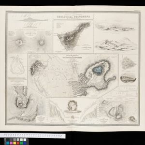
The phenomena of volcanic action: showing the regions visited by earthquakes and the distribution of volcanoes over the globe
1849
Brunei, Cambodia, East Timor, Indonesia, Laos, Malaysia, Myanmar, Papua New Guinea, Philippines, Singapore, Southeast Asia, Thailand, Vietnam
On the main map, the volcanic regions of Southeast Asia are labelled, active and extinct volcanos are marked, and the 1815 eruption of Tumbora (Mount Tambora on Sumbawa) is highlighted. Even more details are shown on an inset map of Southeast Asia.

India (southern sheet)
1824
Myanmar, Malaysia, Indonesia, Singapore, Thailand
The inset map on this map of India features part of mainland Southeast Asia, with the British colonial territories—Straits Settlements, British Burma—highlighted in red, ‘protected states’ in yellow, and ‘independent states’ in green.


