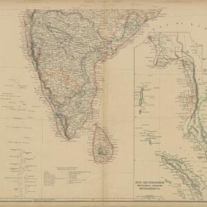
Search

Search Results

India (south part)

event1824

location_onMyanmar, Malaysia, Singapore, Thailand, Indonesia

The inset map on this map of India features part of mainland Southeast Asia: Pegu and the Tenasserim Provinces (Myanmar), Siam (Thailand), and the Malay Peninsula (Malaysia), with the Straits Settlements—Singapore, Malacca, Penang—highlighted in red.

India (southern sheet)

event1824

location_onMyanmar, Malaysia, Indonesia, Singapore, Thailand

The inset map on this map of India features part of mainland Southeast Asia, with the British colonial territories—Straits Settlements, British Burma—highlighted in red, ‘protected states’ in yellow, and ‘independent states’ in green.

India

event1846

location_onSingapore, Malaysia

There is an inset map of the island of Singapore on this map of India. The island is coloured red to indicate it is British colonial territory. The surrounding islands and straits are marked, as well as details of the city such as the Sultan Mosque.

India

event1847

location_onSingapore, Malaysia

There is an inset map of the island of Singapore on this map of India. The island is coloured red to indicate it is British colonial territory. The surrounding islands and straits are marked, as well as details of the city such as the Sultan Mosque.

Geographical distribution of the currents of air

event1849

location_onBrunei, Cambodia, East Timor, Indonesia, Laos, Malaysia, Myanmar, Papua New Guinea, Philippines, Singapore, Southeast Asia, Thailand, Vietnam

A world map showing winds, hurricanes and typhoons, including trade winds, calms, typhoon, monsoon and hurricane regions in Southeast Asia. An inset map shows the approach of the Rodriguez Hurricane towards Java in 1843.

Zoological Geography: Sheet No. 2: Geographical division & distribution of Carnivora (carnivorous animals)

event1849

location_onBrunei, Cambodia, East Timor, Indonesia, Laos, Malaysia, Myanmar, Papua New Guinea, Philippines, Singapore, Southeast Asia, Thailand, Vietnam

A world map showing distribution of carnivorous animals, including in Southeast Asia. Tables list names of species found in each region; their geographical ranges are marked on the map. There is a drawing of 17 carnivore species of the ‘Old World’.

Humboldt's system of isothermal lines: or lines of equal annual mean temperature over the Globe

event1849

location_onBrunei, Cambodia, East Timor, Indonesia, Laos, Malaysia, Myanmar, Papua New Guinea, Philippines, Singapore, Southeast Asia, Thailand, Vietnam

A world map, including Southeast Asia, showing isothermal lines—lines that join locations of the same temperature—of annual mean temperature. There are also isobars (lines that join locations of the same barometric pressure).

Mountain chains in Asia & Europe

event1849

location_onCambodia, Indonesia, Laos, Malaysia, Myanmar, Philippines, Singapore, Thailand, Vietnam

Mountain chains are represented by black lines; volcanoes by black dots. Three insets maps: expansion of Reguain—island of Taung-ywa, off the coast of Myanmar—due to volcanic activity; geology of Java (with heights of mountains); volcanoes of Luzon.

Physical chart of the Indian Ocean: shewing the temperature of the water, the currents of the air and ocean, directions of the wind, districts of hurricanes, regions of the monsoons & ty-foons, trade routes &c&c.

event1849

location_onBrunei, Cambodia, East Timor, Indonesia, Laos, Malaysia, Myanmar, Papua New Guinea, Philippines, Singapore, Southeast Asia, Thailand, Vietnam

Chart of the Indian Ocean, showing climate and weather-related data, including around the seas and straits of Southeast Asia where trade routes are marked, along with monsoon and typhoon regions, and currents during the different monsoon seasons.

Physical chart of the Pacific Ocean or Great Sea (Mare Pacifico): Showing the currents & temperature of the ocean, the trade routes &c.

event1849

location_onEast Timor, Indonesia, Papua New Guinea, Philippines

Chart of the Pacific Ocean, showing climate and weather-related data, including around the seas and straits of eastern Southeast Asia where maritime trade routes are marked, along with monsoon regions, ocean temperatures and currents.

S.E. Peninsula and Malaysia

event1849

location_onBrunei, Cambodia, East Timor, Indonesia, Laos, Malaysia, Myanmar, Papua New Guinea, Philippines, Singapore, Southeast Asia, Thailand, Vietnam

The colonial possessions of Britain, the Netherlands, Spain, Portugal and Denmark are shown on this mid-19th century map of Southeast Asia. There are inset maps of Penang Island and Singapore, and text describing the region’s colonial history.

Survey of the geographical distribution and cultivation of the most important plants which are used as food for man: with indications of the isotheres & isochimenes, or lines of equal summer & winter temperature

event1849

location_onBrunei, Cambodia, East Timor, Indonesia, Laos, Malaysia, Myanmar, Papua New Guinea, Philippines, Singapore, Southeast Asia, Thailand, Vietnam

Map of important food crops (rice in Southeast Asia). Inset maps of tea, cassia, pepper, cinnamon, clove, nutmeg, sugar, coffee. With isothermal lines—lines joining locations of same temperature—of summer and winter temperatures, and plant drawings.

close

  • Filter from 1824 to 1898

Current results range from 1824 to 1898